Bolton and Manchester in
1924
(or possibly 1937)
![[image] small picture of 1924 map](title.jpg "Greatly reduced - part of the 1924 Ordnance Survey Map")
Part of
Joyce's World of Transport Eclectica
Welcome to the 1924(ish) Ordnance Survey "One Inch" map of Bolton and Manchester.
Good news everyone! I now know when this map was actually produced by Ordnance Survey - thanks to my friends on the SABRE roads group ("the UK's premier discussion forum for roads and all things related").
Being a railway buff, I tend to look at the railway lines and not the roads, so I hadn't noticed the major new highways of the 1930s such as the A580 (East Lancs Road), the A34 (Kingsway) and the A5103 (Princess Parkway). Various people have contacted me to point out these anachronisms and question the map's age, but only one person has been able to date the map accurately. Step forward Mr Graham Cornell of Tewkesbury, who wrote with this most useful bit of decryption:
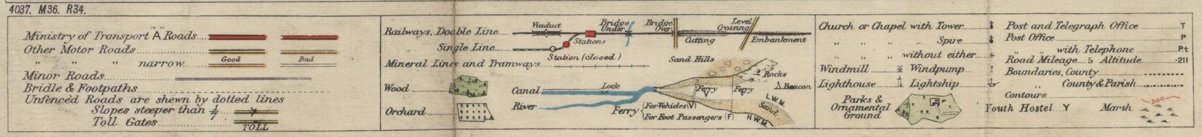
"You might be interested to know that your map actually dates from 1937, not 1924. You can tell this from the print code on the bottom left, which reads "4037. M36. R34." This means that 4000 copies of the map were printed in 1937, with minor corrections made to 1936 and roads revised to 1934. In practice the suburbs of the main cities won't have been revised much since the map was first published in 1924, but the main roads will have been. A number of roads, such as the East Lancs Road (the A580) were built after 1924 and do not appear on the first printing of this map."
Anyway, whether the map is 80 years old or just 67 years old, it's still had its pension and its bus pass for quite a while (no free telly licence yet though), and it is therefore still out of copyright.
Scanned at original scale, the map weighs in at nearly 42 megabytes as a jpeg file - and a colossal 116 megabytes as a TIF file. Not surprisingly, I keep the original scans on a compact disk. For this web-based version, I've had to reduce it in size a little, and for ease of downloading, I've broken the map into 12 segments. These are coded A to L - A to D are the top row, E to H are the middle row and I to L are the bottom row. Put your cursor over the part of the map that interests you, and a Title panel should pop up to tell you which segment you're in and which towns it covers. (Yes, I've learned a bit of new coding that works in most browsers, including Mozilla.)
Click on part of the map and it will take you to segments at two different sizes. The first version gives you the map at a relatively small size, to keep download times to a minimum. These sections are between 400 and 700 KB each. They also overlap to some degree, enabling you to see the whole of a particular area's railways in one picture. From here you can navigate to a second version of the map. This gives you segments at a larger size, typically 1.2 MB each, and are as close to the original scale as scanning technology permits. These "full scale" versions do not overlap, so you can if you wish save them to your own computer, then re-assemble them using a graphics editor to give you the whole map or just the particular area that interests you.
The whole point of this exercise is of course to allow you to see all the details of the map. To do this, you'll need to scroll down and across to see some parts of each map segment. However, some browsers like to resize the map segments so that they fit neatly into your window. Internet Explorer does this by default. To stop it, go into Tools, select Internet Options and then the Advanced tab. Scroll down this window until you reach Multimedia, then uncheck the box for "Enable Automatic Image Resizing". (Yes, I could just write individual pages for each segment, specifying the exact image sizes in the HTML code, but then it would take another week out of my life.)
You can download the key, scale and copyright details in separate windows if you like. This may help you to interpret the individual map segments more easily. Otherwise you'll only find the key, scale etc on specific sections of the map (I, K, L and M).
Although the map is out of copyright, I do need to tell you that Ordnance Survey has asserted its right to be identified as the author of the map, and that it is Sheet 36 of the "Popular Edition One Inch Map" series (so much better than the Unpopular Edition). The scale is of course One Inch to the Mile or 1:63,360. You can buy reprints of all or part of this map by contacting Ordnance Survey, either directly or through map shops such as Stanfords and The Stationery Office.
Do bear in mind the age of this map! The images on this site are scanned from an elderly piece of paper and they include the original's folds, tears, pencil marks and other ravages of time. Apologies in advance if the bit you really want to see is obscured or blurred.
Back to the top
If you're interested in old maps generally, I recommend the GenMaps site. It has links to excellent scans of many old maps covering all sorts of places in Britain. The site includes a list of old maps of Lancashire, going back as far as 1579.
Somewhat belatedly, I have been made aware of the Historic OS Maps pages on the SABRE website. It covers most of the country and has a wide selection of dates to choose from.
This page was last updated in May 2012. Comments on this site, or notice of any broken links, are always welcome: send me an e-mail.
![[image] Map segment A](t1924a.jpg "Segment A - Wigan, Hindley and Horwich")
![[image] Map segment B](t1924b.jpg "Segment B - Bolton, Bury and Swinton")
![[image] Map segment C](t1924c.jpg "Segment C - Bury, Radcliffe and Heywood")
![[image] Map segment D](t1924d.jpg "Segment D - Rochdale, Oldham and Middleton")
![[image] Map segment E](t1924e.jpg "Segment E - Earlestown and Leigh")
![[image] Map segment F](t1924f.jpg "Segment F - Leigh and Glazebrook")
![[image] Map segment G](t1924g.jpg "Segment G - Manchester and Salford")
![[image] Map segment H](t1924h.jpg "Segment H - Manchester, Ashton and Stalybridge")
![[image] Map segment I](t1924i.jpg "Segment I - Winwick, Warrington and key to map")
![[image] Map segment J](t1924j.jpg "Segment J - Glazebrook and Altrincham")
![[image] Map segment K](t1924k.jpg "Segment K - Altrincham, Cheadle and scale of map")
![[image] Map segment L](t1924l.jpg "Segment L - Cheadle, Stockport and Marple")