Map of Central London in
1935
Part of
Joyce's World of Transport Eclectica
Welcome to the 1935 Railway Clearing House map of Central London. Click here to download it. Use whatever passes for a Back feature on your browser to return to this page. Be warned - it's big - over 700 KB.
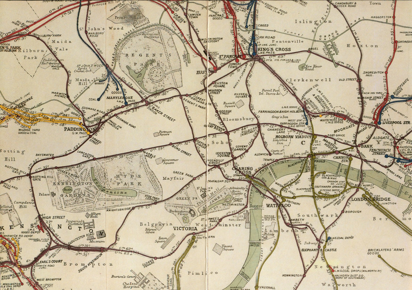
This is a partial reproduction of the official Railway Clearing House map for 1935, showing all the stations in Central London - Underground as well as surface. I've scanned it from, of all places, a Christmas card sent out in about 1991 by British Rail. (This explains why there's a vertical fold down the middle of the map.)
To be precise, it was sent by the Kings Cross/St Pancras Project Team. They were working on a number of schemes which would have seen the redevelopment of those two stations, and the associated Underground and Thameslink stations, as part of such projects as Thameslink 2000 and the Channel Tunnel Rail Link. As I write this today, in 2004, the only part of the scheme going ahead is CTRL, and there is a huge hole in the road outside St Pancras where the new London Underground ticket hall should be built - if it gets through a Department for Transport review.
But in 1991, or whenever it was, all these schemes were still bright ideas for the future. And this extract from the 1935 map was intended to reflect some of the complications that the planners faced in trying to thread new main line railway tunnels and new pedestrian passages above, below and between the tangle of Tube and main line tunnels in this area.
The colours on the map are not explained but it doesn't take much effort to work out that purple (the main colour) shows lines owned by the London Passenger Transport Board while the other colours show the "Big Four" main line railways. Yellow is the Great Western; red is the London, Midland and Scottish Railway; blue is the London and North Eastern Railway; and green is the Southern Railway. Notice the odd spots of colour in unexpected places, usually where one main line railway has a coal or goods depot in the territory of another company.
And notice also a few other things: the route of the Grand Union Canal, criss-crossing the railways along the top of the map; the location of the Railway Clearing House itself on, I think, Eversholt Street; the complicated route of the two branches of the Northern Line around Euston, where they pass but go in opposite directions.
But above all, notice how very different this map appears to our eyes, accustomed as we are to Harry Beck's classic "wiring diagram" of the Underground system. Harry Beck introduced his map just two years before this edition of the RCH map was published.
The one piece of railway missing is the Post Office Railway, already built and operational at this date but not relevant to the activities of the Railway Clearing House.
You can see more reproductions of Railway Clearing House maps in Wikimedia Commons.
This page was last updated in December 2009. Comments on this site, or notice of any broken links, are always welcome: send me an e-mail.
Visits to this page since December 2004: